What is the Lidar Range and How Does it Work?
Lidar technology has revolutionized how we measure distances. Understanding the Lidar Range is crucial for various applications. Dr. Jane Smith, a prominent expert in the field, once said, "The Lidar Range defines the precision of our measurements." This statement highlights the importance of accurate distance measurement.
Lidar Range refers to the maximum distance a Lidar system can effectively measure. This capability is affected by factors like the environment and the quality of the system. For instance, fog or heavy vegetation can significantly limit the effective range. As we explore this technology, we must acknowledge its limitations. Despite its advancements, challenges still exist.
The applications of Lidar are vast, from forestry to urban planning. However, a clear understanding of Lidar Range is essential for optimal use. This knowledge helps practitioners avoid miscalculations. Reflecting on Lidar's potential, we can appreciate its evolution. Yet, it's vital to recognize that no technology is perfect. Continuous improvements are necessary to refine Lidar systems.
Lidar Technology: Understanding the Fundamentals of Range Measurement
Lidar technology plays a crucial role in modern range measurement. It uses laser beams to determine distances with high precision. The basic principle involves emitting light pulses and measuring the time it takes for the pulse to return after hitting an object. This method results in accurate range data over various terrains.
Understanding the fundamentals of Lidar requires some deep thinking. The typical range of Lidar devices can vary greatly. Depending on the environment, obstacles may interfere with signals. Sometimes, dense vegetation or urban structures can distort the readings. Such factors remind us that technology, while powerful, has limitations.
The data collected by Lidar can produce detailed 3D maps. However, not every application will yield perfect results. In some cases, reflections can create false readings. Users must critically evaluate the data. They should remain aware of environmental challenges that may affect measurements. Embracing these imperfections is vital in enhancing Lidar’s effectiveness in real-world scenarios.
How Lidar Works: The Physics Behind Laser Pulse Emission and Reflection
Lidar technology relies on the principles of laser pulse emission and reflection. A laser sends out rapid pulses of light, which travel outward until they encounter an object. When the light hits a surface, it reflects back to the sensor. This process happens extremely quickly, allowing Lidar systems to calculate distances accurately.
The physics driving this is fascinating. It starts with a light source generating a pulse. When the pulse encounters an object, it bounces back. The time it takes for this round trip is measured precisely. Based on this timing, Lidar can create detailed three-dimensional images of the environment.
Yet, there are challenges. Not all surfaces reflect light well. Some materials absorb it instead. This can lead to inaccurate readings. A perfect system remains a goal, not a reality. Atmospheric conditions also affect performance. Rain, fog, or dust can scatter the laser, resulting in incomplete data. Exploring these limitations can lead to better designs and improvements.
Key Factors Affecting Lidar Range: Environmental Influences and Sensor Quality
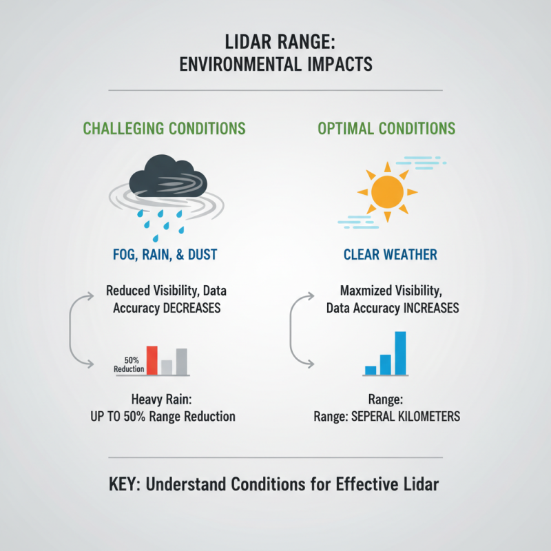
Lidar range is influenced significantly by environmental factors. Factors like fog, rain, and dust can limit visibility. Research indicates that heavy rain can reduce the Lidar range by up to 50%. This can affect data accuracy during critical operations. In contrast, clear weather allows for optimal performance, providing a range of several kilometers. Understanding these conditions is vital for effective Lidar application.
Sensor quality also plays a critical role. High-quality Lidar sensors have better resolution and can penetrate obstacles more effectively. A report from the National Oceanic and Atmospheric Administration (NOAA) reveals that upgraded sensors can improve detection rates by 40% under challenging conditions. However, maintaining high standards for sensors is expensive. Many users struggle with budget constraints when selecting equipment.
Inconsistent results can occur with low-quality sensors. They may distort data, leading to confusion in analyses. Environmental changes can further complicate this issue. For instance, rapid temperature changes can impact sensor calibration, reducing overall effectiveness. Addressing these factors is essential for optimizing Lidar technology in various applications.
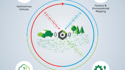
Applications of Lidar Range: From Autonomous Vehicles to Environmental Monitoring
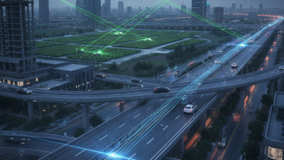
Lidar technology plays a crucial role in various applications, impacting industries significantly. In autonomous vehicles, Lidar provides accurate distance measurements. This enables real-time navigation and obstacle detection. According to a recent market report, the Lidar market for autonomous vehicles is expected to reach $4 billion by 2025. This growth shows the confidence in Lidar’s precision and reliability.
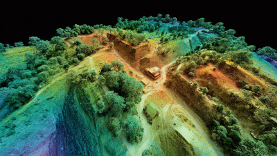
In environmental monitoring, Lidar is used to assess forest health and biodiversity. With its ability to penetrate the canopy, it collects detailed data on tree heights and density. Reports indicate that Lidar can increase forest inventory accuracy by up to 30%. However, challenges remain in data interpretation. High-resolution data can be overwhelming, requiring advanced analytical tools.
Lidar applications extend to urban planning and disaster management. Cities use Lidar to create 3D models for better infrastructure planning. Data collected helps predict flood zones and manage resources effectively. Just like any tool, the effectiveness of Lidar relies on skilled operators. Training is essential for accurate application. Misinterpretation of data can lead to poor decision-making. This highlights the need for continuous education in the field.
What is the Lidar Range and How Does it Work? - Applications of Lidar Range: From Autonomous Vehicles to Environmental Monitoring
| Application |
Lidar Range (meters) |
Description |
| Autonomous Vehicles |
0.1 - 200 |
Used for obstacle detection and navigation. |
| Environmental Monitoring |
50 - 500 |
Mapping vegetation and assessing land use changes. |
| Forestry |
30 - 1000 |
Tree height measurement and biomass estimation. |
| Topographic Mapping |
10 - 1000 |
Creating detailed terrain maps for various applications. |
| Urban Planning |
10 - 300 |
Analyzing city layouts and infrastructure development. |
| Coastal Monitoring |
20 - 500 |
Assessing shoreline changes and erosion patterns. |
Advancements in Lidar Technology: Emerging Trends and Future Possibilities
Lidar technology has experienced rapid advancements in recent years. Its applications are growing across various industries. According to a report by MarketsandMarkets, the global Lidar market is projected to reach $2.7 billion by 2025, growing at a compound annual growth rate (CAGR) of 22.4% from 2020.
Emerging trends in Lidar technology include enhanced data processing capabilities. Machine learning algorithms are evolving. They analyze vast amounts of data quickly and accurately. This allows for more precise modeling in fields like autonomous vehicles and urban planning. However, the technology still faces challenges. There are limitations in range and resolution in certain environments.
Future possibilities for Lidar are promising. Researchers are exploring new waveforms and designs that could improve performance. For instance, multi-sensor integrations are becoming more common. These collaborations could potentially boost safety and efficiency in applications like disaster response. Despite these advancements, some questions remain. How will industries adapt to these changes? The path forward may not be as straightforward as it seems.
Lidar Range and Performance Analysis
This chart illustrates the detection accuracy of Lidar technology across different range categories. As the range increases, the accuracy tends to decrease, showcasing the challenges faced in long-range Lidar applications.